
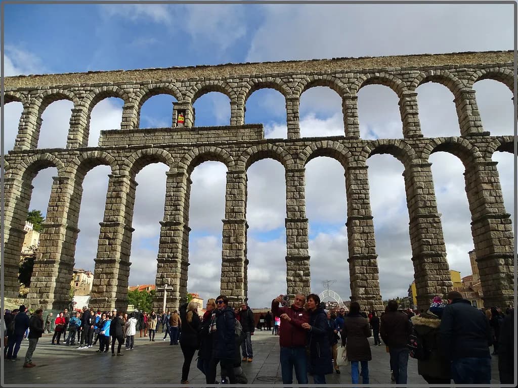
The Aqueduct of Segovia: What to See and How to Visit
The Aqueduct of Segovia is a Roman water channel carried on arches across Plaza del Azoguejo, at the edge of the historic centre. You see it for free from the square, and it takes minutes to reach on foot from the old town rather than a dedicated excursion.
Its draw is not only size but construction: the elevated section is a long run of tall arches and pillars, and it is most often dated to the late 1st or early 2nd century AD. Plan it as the first thing you do on arrival, because the plaza is the natural way into the city rather than a sight you detour to.
What the Aqueduct of Segovia is and why it matters
This is an aqueduct in the literal sense: a channel that brought water from the mountains into the city, carried over a valley on a bridge of arches where the ground dropped away. The structure at Plaza del Azoguejo is the surviving showpiece of that system and the defining historical feature of Segovia.
What makes it worth more than a photograph is that it was engineered, not merely built. Roman surveyors had to run a channel from a mountain source along the contours of the land at a constant gradient so that the water arrived at the right height to fill cisterns, fountains and baths, and the arches are the visible part of that longer line.
The plaza version of the story is the one most visitors miss: this is a working entrance to the historic centre, and you will almost certainly walk beneath the arches on your way into town. Treat the first sighting as part of your arrival rather than a separate stop.
Where it is: Plaza del Azoguejo and the old-town gateway
The aqueduct stands at Plaza del Azoguejo, on the western approach to the old town, and the square functions as the gateway through which most arrivals enter the historic centre. The location is the single most useful fact for planning: everything else in the old town sits above and behind it.
Because the monument is embedded in the street layout rather than fenced off in a park, there is no gate to queue at and no turnstile between you and the view. The trade-off is that the square is a busy thoroughfare, so the calmest look at the stonework comes from standing back at the edges of the plaza rather than directly under the tallest arches.
How to get there
Segovia sits in Castile and León, northwest of Madrid, and the aqueduct is the landmark that tells you that you have reached the centre. Once you are in the old town, navigation is simple: walk downhill or along the main approach until the arches appear across the square.
Arriving by high-speed train, you reach Segovia's AVE station outside the city and need a bus or taxi for the last stretch into town; the local bus stops within sight of the aqueduct, which is how the monument becomes the first thing you see. Allow for that connection when you plan your arrival, and check current train and bus times before travelling.
If you are staying overnight, the square is an easy reference point for finding your way back, and it sits close enough to the cathedral and the castle that you can walk between them without transport. That compactness is the argument for keeping your base in the old town rather than near the station.
What to look for: arches, pillars and no mortar
Count the rhythm of the structure rather than admiring it as a single mass: the elevated stretch runs roughly 3,000 feet and reaches about 100 feet at its highest point above the plaza, carried on 166 arches and 122 pillars. Those proportions are why the aqueduct dominates the square even from a distance.
Then look at the joints. The blocks are fitted together without mortar or cement, which is the detail that surprises people who expect Roman masonry to be glued with something; the precision of the cut stone is doing the work instead.
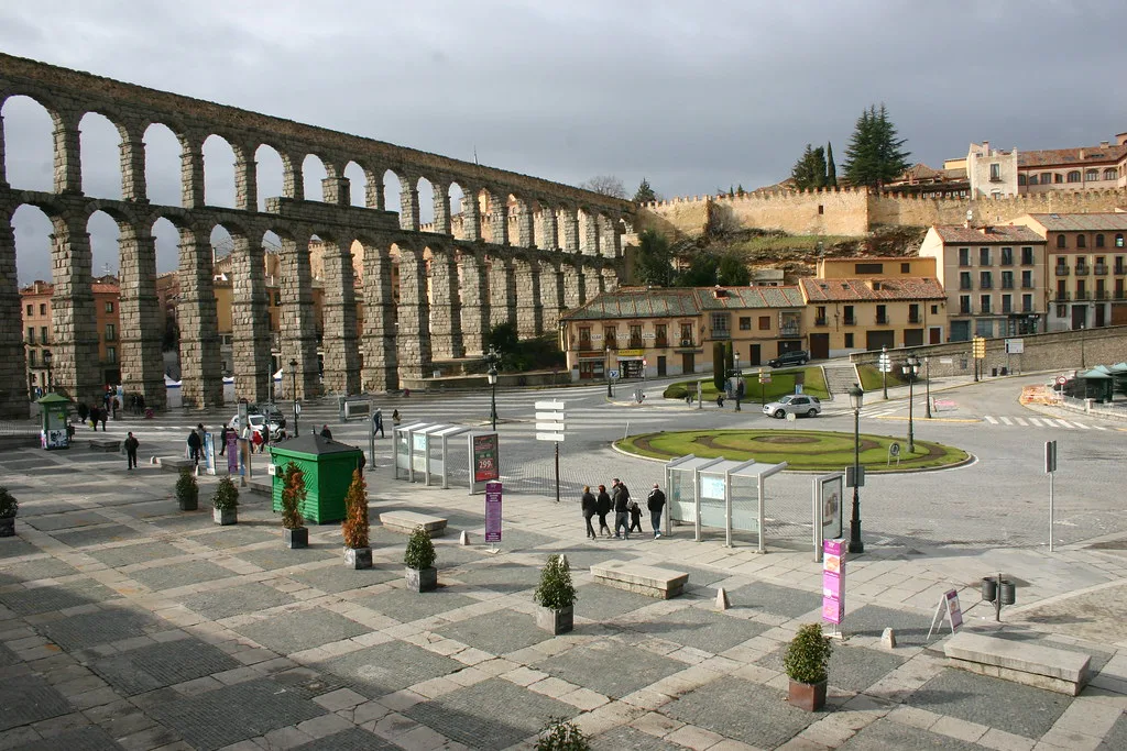
Look at how the arches are stacked and carried, and note how the pillars thicken towards the base to take the load. The stone is granite, weathered dark in places, and the contrast between the shadowed underside of the arches and the sunlit face is what makes the structure so photogenic.
How it works: the source in the mountains and the buried channel
The water came from the Río Frío in the mountains roughly 11 miles from the city, and most of the channel ran underground. The arched section exists only where the route had to cross the deep valley at Segovia, which is why the monument reads as a bridge even though its job was delivery, not crossing.
The engineering challenge was the gradient: a channel that drops too steeply empties too fast and one that levels out stalls, so the route had to follow the land's contours at a constant, gentle slope to arrive at the correct elevation in the city. Standing in the plaza, that invisible precision is the real achievement on display.
The date: late 1st or early 2nd century AD
The aqueduct is generally dated to the late 1st or early 2nd century AD, which places it in the Roman Empire's mature imperial period. The dating is not fixed, and the emperors most often associated with the work are Domitian and Trajan, which tells you the construction belongs to that era rather than to a single documented year.
For a visitor the practical point is simpler: you are looking at something close to two thousand years old that has survived earthquakes, weather and the growth of the city around it. Read it as infrastructure that outlasted its purpose, not as a ruin preserved in isolation.
How long to allow and the best way to spend it
Budget around 30 to 45 minutes at the aqueduct itself: enough time to walk the length of the square, look up at the arches from several angles and read the stonework. That is the honest figure, and it is better to know it than to build a half-day around a single structure you can see in one sweep.
The sensible sequence is to arrive, see the aqueduct, then climb into the old town for the rest of the day and return to the plaza in the evening when the light softens. The square in front of the arches is a great place to linger and gives you space to stand back for a full-height view.
If you are weighing up whether Segovia deserves a day trip or an overnight stay, the aqueduct alone does not settle it; the surrounding old town does. For a direct comparison of the same decision at another destination, read how many days in Segovia you actually need. Work out your time budget before booking transport so you are not rushing the monument and missing the streets behind it.
Looking up: angles and photographs from the plaza
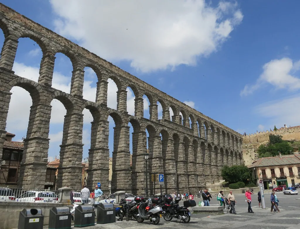
The classic view is from the square itself, standing back far enough to take in the tallest arches from base to top, with the upper tier visible above. Because the monument is a facade as well as a structure, the far side of the plaza gives you the cleanest full-height frame.
For a different angle, walk up into the old town and look back down: the aqueduct reads as a wall of arches threading between buildings, which explains why it became the city's emblem. Photograph it in the morning or late afternoon when the sun rakes across the granite and the arches cast defined shadows.
Do not expect to climb or walk along the channel; the aqueduct is viewed from street level, and the plaza and the streets around it are where the experience happens. Plan your photographs around the square rather than around access to the top.
What is nearby once you have finished
From the aqueduct, the old town rises behind you, and the Alcázar de Segovia sits at the far end of the historic centre within walking distance. It is a distinct visit with its own ticket arrangements, so check those separately rather than assuming one entry covers both.
The Catedral de Segovia stands between the square and the castle, on Calle Marqués del Arco, and makes a natural second stop on the walk uphill. Together with the aqueduct these are the three anchors of a straightforward old-town circuit.
For context on the city rather than the Romans, the Museo de Segovia, housed in the Casa del Sol, covers local history and art and gives you somewhere indoors if the weather turns. It is a short walk from the aqueduct and works well as a filler before lunch or dinner.
Eating in Segovia follows Spanish hours: lunch runs from about 1.30pm to 4pm and dinner starts around 8.30pm to 9pm, so plan your walk around those windows rather than expecting a full menu at 6pm. The cluster of guides for the city covers the sights in more depth if you want to build out the rest of your day.
Practical points to check before you go
The aqueduct is an outdoor monument viewed from public streets, so there is no ticket to buy for the view from Plaza del Azoguejo and no opening time to work around. Any interior access, guided tour or combined ticket is a separate matter, and the city's tourism office publishes what is currently available.
Before you travel, confirm train and bus connections from Madrid and the onward link from the AVE station into the city, since the station is outside the centre. Check the tourism office's pages for any temporary access restrictions around the monument, and pack for strong sun in summer because the square offers little shade.
Plan Your Visit
See the aqueduct first, from Plaza del Azoguejo, then use the square as your way into the old town rather than a destination in itself. Half an hour to look, photograph and read the stonework is time well spent, and the rest of the day belongs to the streets above.
The monument rewards attention to detail more than time: no mortar, a constant gradient, a long buried channel from the mountains and a double row of arches holding it all up. Arrive knowing that, and a quick look becomes the most memorable stop of the day.
Frequently Asked Questions
When was the Aqueduct of Segovia built?
It is generally dated to the late 1st or early 2nd century AD, in the mature imperial period, with Domitian and Trajan the emperors most often linked to the work. The dating is not fixed to a single documented year, so treat the century rather than a precise date as the reliable answer.
Can you walk on the Aqueduct of Segovia?
No. The aqueduct is viewed from street level, with Plaza del Azoguejo the main place to stand back and take in the full height of the arches. There is no climbing or walking along the channel, so build your visit around the square and the streets that pass beneath it.
Do you need a ticket to see the Aqueduct of Segovia?
The view from Plaza del Azoguejo is free, because the monument stands in public streets rather than behind a gate. Guided tours, interior access or combined tickets are separate products, and the city's tourism office is the place to confirm what is currently running.
How much time should you allow at the Aqueduct of Segovia?
Around 30 to 45 minutes covers the square, the arches seen from several angles and a proper look at the stonework. Most visitors then continue uphill into the old town, so it is better planned as the opening move of a day rather than as a half-day outing.
How do you get to the Aqueduct of Segovia from the AVE station?
Segovia's high-speed station sits outside the city, so you need a local bus or a taxi for the final stretch. The bus stops close to the aqueduct, which makes the monument the first thing many arrivals see. Check current times before you set out.